-
Services
-
expand_more
Back
Services
-
-
expand_more
Back
Rates & Property
- Setting the Rates
- Revaluation and how it affects rates
- Rates Dates & Payment Options
- Changing your details
- Property Information Search
- Online Rates Payments
- Rates Rebates, Remission & Postponement
- Short-Term Visitor Accommodation
- Queenstown CBD Transport Rate for Queenstown Town Centre Properties
- Wastewater Rates for Cardrona
- Other Information
- Rates FAQs
-
-
expand_more
Back
Rubbish & Recycling
- How we recycle in the Queenstown Lakes District
- Cut your waste
- Commercial Services
- Public place litter bins and illegal dumping
- Rubbish & Recycling Collection
- Recycling Centres
- Transfer Stations
- Solid Waste Assessment
- Waste Minimisation Community Fund
- Waste Minimisation for Businesses
- Zero Waste Events
- Green and food waste
- Construction and demolition waste
-
-
expand_more
Back
Resource Consents
- Do I need a resource consent?
- Change, extend or surrender a resource consent
- Before you apply
- Apply for a resource consent
- Non-compliance & monitoring
- Notified consents
- Land Developments and Subdivisions
- Need help?
- Current resource consents
- eDocs
- FAQs
- Practice notes and guidance
-
-
expand_more
Back
Alcohol Licensing
- Alcohol Public Notices
- Find the right alcohol licence and apply
- Alcohol licence fee calculator
- Renew and/or vary your alcohol licence
- Manager's certificates
- Legal requirements for licence holders
- District Licensing Committee decisions
- ARLA annual report
- Alcohol-Free Areas In Public Places
- Have your say on alcohol licence applications
- All alcohol licensing forms
- Gambling Information
-
-
Do It Online
-
expand_more
Back
Do It Online
-
-
expand_more
Back
Registrations
- Register your Dog
- Register for a transfer or refund of dog registration fee
- Renewal for Campgrounds and Offensive Trade Registrations
- Activities in a Public Place - Registration/Application Form
- Register as a Homestay
- Register as Residential Visitor Accommodation
- Register for our public notification list
- Register to speak at Public Forum
- Register for Kerbside Collection Services
- No Spray Register
-
Community
Community
Ngā Hapori
- Manaaki
- Newcomers Guide
- Welcoming Communities
- Arts, Culture and Heritage
- Community Connect
- Citizenship Ceremonies
- Community Associations and Groups
- Community Funding
- Community Research
- Community Wellbeing
- Economic Development
- Emergency Management
- Energy Saving Tips
- Event Planning and Venues
- Māori Community
- Managing the risk of wildfire
- Population and Demand
- Summerdaze
- Tuia Programme
- Venue Hire

2025 Quality of Life Survey
Our annual survey is now open and your views are important!
-
Recreation
Recreation
Kā mahi a te rēhia
- Queenstown Events Centre
- Wānaka Recreation Centre
- Paetara Aspiring Central
- Swim
- Learn to Swim
- Golf
- Kids' Recreation
- Sport & Rec Venues and Contacts
- Courts and Fields
- Memberships - Join Today
- Join the Sport & Rec Team
- Responsible Camping
- Parks and Walkways
- Lakes and Boating
- Mountain Biking
- Horse Riding
- Splash Café
- Physiotherapy
- Playgrounds
- School Holiday Programmes
- This Is Sport & Recreation
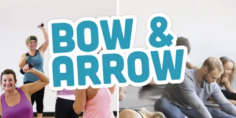
Bow & Arrow
A fitness programme in Arrowtown featuring strength and stretch elements. Book your spot now!
-
Your Council
-
expand_more
Back
Your Council
-
-
expand_more
Back
Council Documents
- Long Term Plan (LTP)
- Archived Agendas & Minutes
- Annual Plans
- Annual Reports
- Asset Management Plans
- Awarded Council Contracts
- Bylaws
- Capex Quarterly Update
- Monthly Reports
- National Policy Statement - Urban Development 2020 (NPS-UD)
- Policies
- Pre-election reports
- Queenstown Lakes Spatial Plan
- Reserve Management Plans
- Section 10A Reports
- Small Community Plans
- Strategies and Publications
- Submissions from QLDC
-
-
expand_more
Back
Council Projects
- Project Tohu
- Queenstown Town Centre Arterial
- McPhee Park Playground
- Blue-Green Network Plan
- Frankton Track Wastewater Upgrades
- Aubrey Road Wastewater Pipe Upgrades
- Luggate Water Upgrades
- Kingston Infrastructure Works
- Queenstown Town Centre Street Upgrades
- Way To Go
- Our Water Done Well
- Upper Clutha Wastewater Conveyance Scheme
- Shotover Wastewater Treatment Plant Stage 3 upgrades
- Short term approach for managing wastewater discharge
- Long term solution for Shotover Wastewater Treatment Plant
- Smart Water Meters Trial
- Environmental Monitoring System
- Lakeview Development
- Mount Iron Reserve Management Plan
- Project Manawa
- Wānaka Airport Certification
- Wānaka Airport Future Review
- Improving housing outcomes
- Queenstown Lakes Home Strategy
- Upgraded Two Mile UV Treatment Plant
- Frankton Road Watermain Upgrades
- Glenorchy Water Treatment Upgrades
- Upper Clutha Safety Improvements Programme
- Cardrona Valley Water Supply Scheme
- Schools to pool active travel route
- All-weather turf at Queenstown Events Centre
- Arthurs Point to Queenstown shared path
- 101 Ballantyne Road Masterplan
- Ballantyne Road Upgrade
- Cardrona Valley Wastewater Upgrade
- Glenorchy Reservoirs
- Frankton Campground
- Frankton Stormwater Upgrade
- Marine Parade Upgrades
- Mayoral Housing Affordability Taskforce
- Shotover Country Borefield and Treatment Plant
- Proposed Visitor Levy
- Ladies Mile Masterplan
- Recreation Ground Wastewater Pump Station and Rising Main
- Luggate Memorial Centre
- Te Kararo Queenstown Gardens
- Western Wānaka Water Supply Upgrade
- Shotover Bridge Water and Wastewater Main
- Te Tapuae Southern Corridor
- Glenorchy Marina Carpark
- Wānaka Lakefront Development Plan
- Travel Demand Management Programme
- Peninsula Bay Reserve Regeneration
-
-
expand_more
Back
District Plan
- Operative District Plan
- Proposed District Plan
- ePlans
- National Policy Statement-Urban Development (District Plan Amendments)
- Urban Intensification Variation
- Te Pūtahi Ladies Mile Variation
- Private Plan Change 1 - The Hills Resort Zone
- Upper Clutha Landscape Schedules Variation
- Priority Area Landscape Schedules
- Special Zones Review
- District Plan Maps
- A Guide to Plan Changes
- Planning Matters - Planning & Development Newsletter


- Community
- Manaaki
- Newcomers Guide
- Welcoming Communities
- Arts, Culture and Heritage
- Community Connect
- Citizenship Ceremonies
- Community Associations and Groups
- Community Funding
- Community Research
- Community Wellbeing
- Economic Development
- Emergency Management
- Energy Saving Tips
- Event Planning and Venues
- Māori Community
- Managing the risk of wildfire
- Population and Demand
- Summerdaze
- Tuia Programme
- Venue Hire
Weather Event - October 2025
We’re expecting further heavy rain and strong winds across the Queenstown Lakes District over the coming days.
The QLDC Emergency Operations Centre is closely monitoring conditions alongside Otago Regional Council and Otago Emergency Management. This page will be updated regularly.
Last updated: 6.00pm, 22 October 2025.
Quick links
Snapshot of situation
-
Heavy rain and strong winds are forecast for Thursday 23 October, from 1.00am – 12.00pm.
- Rivers in the Lake Whakatipu catchment area (including the Dart, Rees, Arrow, Nevis, Shotover and Kawarau rivers) and Lake Wānaka catchment (including the Matukituki, Lindis, Wilkin and Cardrona Rivers) have risen in response to recent rain. While the rivers are now receding, the rain forecast for Thursday will result in further rises from Thursday afternoon/evening.
-
Further heavy rain is forecast early next week.
-
Lake Whakatipu: monitoring is showing the potential for surface flooding and localised ponding in low-lying areas such as Beach and Rees Street in Queenstown, as water enters through the stormwater system. Low lying areas of Kingston foreshore and Glenorchy will also likely be affected.
-
Glenorchy township: there is potential for localised flooding in the north-west part of the township and around walking tracks and footbridges. The EOC is working with the Glenorchy Community Resilience Group to communicate directly with potentially affected residents.
-
Lake Wānaka: some surface flooding is possible around low-lying lakefront areas.
- More detailed information on monitoring can be found below.
-
Stay safe out there and look after each other. Always take care around waterways and never drive or walk through floodwaters.
Otago Regional Council monitoring
Otago Regional Council monitors lake and river levels. Current modeling shows:
-
Lake Whakatipu is sitting around 310.7m and forecast to rise to approximately 311.6m by Friday morning (24 October).
-
Glenorchy Lagoon is sitting at around 311.5m, but further rain could see it rise again above 312.6m (the overtopping threshold) late Thursday or early Friday.
-
Lake Wānaka is currently 278.6m and forecast to reach around 279.7m by Friday morning.
- View ORC lake level monitoring data here
Information for businesses
All lakefront businesses are asked to take some simple steps to be prepared:
-
Check that drains, gutters, and sump covers are clear of debris.
-
Check grease traps are clean
-
Ensure insurance and emergency contact information is up to date and easily accessible
-
Review Business Continuity Plans and ensure staff are aware of safety procedures.
-
Move any at-risk equipment, stock, or electrical items off the floor or to higher ground.
If lake levels rise to the point where businesses are at risk of flooding, we will deploy sandbagging stations in affected areas.
Locations and instructions will be published here on this page, and communicated via social media channels. There will also be clear signage in place.
Road closures
If road closures are required, we will provide a full list on this page. These closures will also be communicated via the QLDC Facbeook page and e-txt.
Remember – never drive or walk through flood waters.
Stay informed and connected
See the resources below for more information on how to stay informed and connected during a weather event.
-
MetService – for the latest weather forecast.
-
ORC Flood Monitoring – for the latest lake levels.
-
QLDC e-txt - make sure you’re signed up for targeted updates on local road closures and other issues affecting your community.
-
QLDC Facebook – for updates on local conditions and preparedness information.
Stay up-to-date
Sign up to our newsletters and stay up-to-date with the latest news, events & information in the Queenstown Lakes District.